| Auteur | Collectif |
|---|---|
| Editeur | FRANCE TOURIMSE |
| Impression | 1929 |
| Etat | Bon état |
| Disponibilité | 1 en stock |
| Prix |
|
| Référence | R240098517 |
|---|---|
| Classement Dewey | 912 |
| Fiche créée le | 13/08/2015 |
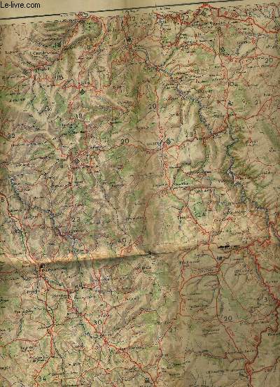
Une carte officielle du service geographique de l'armee - l'auvergne - echelle 1 / 200 000 - carte en couleurs d'environ 60 x 93 cm . par Collectif
FRANCE TOURIMSE. 1929. In-8. Broché. Bon état, Couv. convenable, Dos satisfaisant, Intérieur frais. UNE CARTE OFFICIELLE DU SERVICE GEOGRAPHIQUE DE L'ARMEE - L'AUVERGNE - ECHELLE 1 / 200 000 - CARTE EN COULEURS D'ENVIRON 60 X 93 CM - ENCARTS PUBLICITAIRES AU DOS DE LA CARTE.. . . . Classification Dewey : 912-Atlas, cartes et plans
Dressé, gravé et publié par le service géographique de l'armée. Classification Dewey : 912-Atlas, cartes et plans
Chaque commande est traitée en moins de 2 jours ouvrés. Expédition du lundi au vendredi, toute l'année.
Ouvert du mardi au samedi de 10h à 18h, toute l'année
Abonnez-vous à notre newsletter